
Kimon Onuma, FAIA
|
May 2011 |
[an error occurred while processing this directive] |
|
|
Kimon Onuma, FAIA |
Connections explode to 71 Million
Square Feet for the California Community College System
Connections
In May
of 2009 a presentation was made at Connectivity Week in Santa
Clara CA, that demonstrated for the first time Building Information
Modeling (BIM), Geographic Information Systems (GIS) and building
sensors connected live in the cloud.
| Articles |
| Interviews |
| Releases |
| New Products |
| Reviews |
| [an error occurred while processing this directive] |
| Editorial |
| Events |
| Sponsors |
| Site Search |
| Newsletters |
| [an error occurred while processing this directive] |
| Archives |
| Past Issues |
| Home |
| Editors |
| eDucation |
| [an error occurred while processing this directive] |
| Training |
| Links |
| Software |
| Subscribe |
| [an error occurred while processing this directive] |
Much
has
happened since then and the connections continue to explode as
cloud computing takes off as well. At Connectivity Week we met
new companies and mashed
up with them.
Even in 2011, the building industry is one that is mired in 19th
century processes and tools many of them manual and tedious. Up
to 50% of the effort of designing, constructing and maintaining a
building is waste. This has a huge impact on the
environment. This is incredibly bad but also incredibly good, since the
opportunities to fix it are huge.
Let us automate the 19th century processes that are broken and focus on
value added processes that cannot be easily automated. For
example, creativity and decision making for the most part cannot be
automated but the underlying data that allows us to make intelligent
decisions can be.
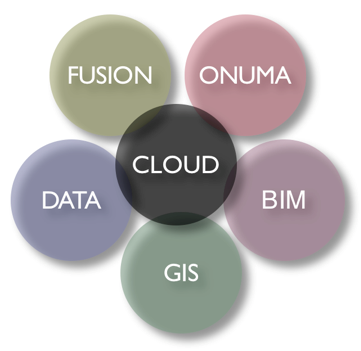
The BIG BANG
The
building industry and environment are infinitely complex and
therefore no single solution is going to solve the problem. The
technologies are all coming together to support a BIG BANG.
Services Oriented Architecture, BIM, GIS, Cloud Computing, Live
Sensors, Web Services and Open Standards are some of the ingredients of
BIG BANG.
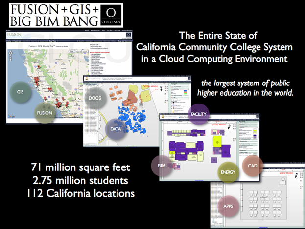
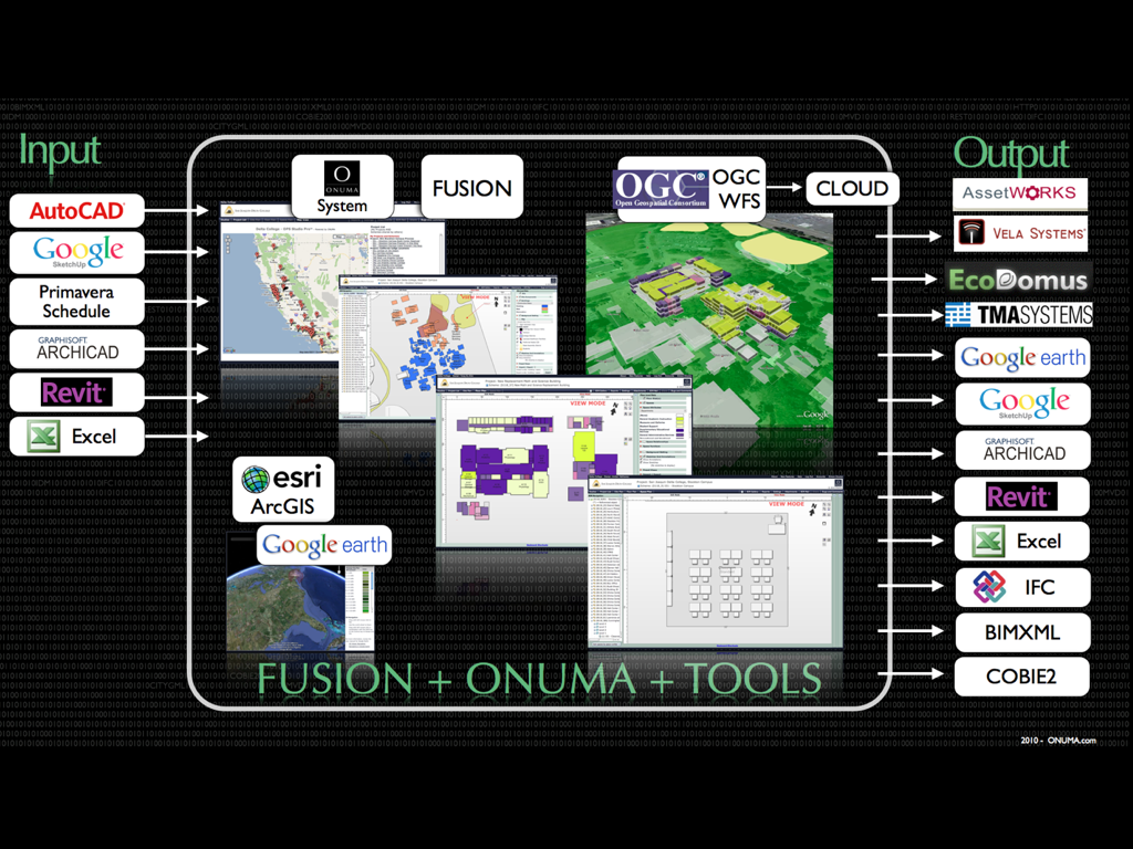
71 Million Square Foot BANG
The
California Community College System (CCC) serves 2.75 million
students at 112 California locations and is the largest system of
public higher education in the world.
On March 11, 2011 the CCC FUSION System (Facilities Utilization, Space
Inventory Options Net) with the entire California inventory of 71
million square feet of buildings and spaces, along with the CCC
Geographic Information System (GIS) Collaborative of campuses and
buildings was brought together with the ONUMA System, making it the
largest cloud computing Building Information Modeling (BIM) + GIS
platform.
In a split second a “BIG BIM BANG” happened between FUSION+GIS+ONUMA to
create a combined platform to dramatically expand the value of FUSION
for CCC.
A wealth of CCC and related facility information is accessible visually
and in real time in a simple online platform thereby saving time and
money through automated synchronization of multiple databases.
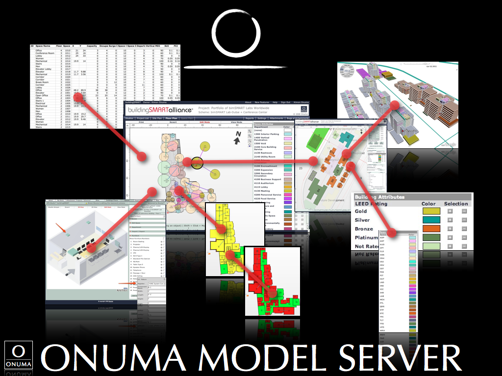
Four Levels of Detail
The goal of the
FUSION+GIS+ONUMA Platform is to have the entire state
at Level 3. The initial goal was to have the entire FUSION
System, which has a common naming and numbering system for the entire
state, linked to the ONUMA System at Level 1. This strategy
allowed for immediate functionality using the FUSION data as a common
foundation to continually update the rest of the building as the data
is collected in the future.
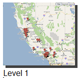
Level 1
The
initial launch of the FUSION+GIS+ONUMA Platform includes the entire
state’s data of classrooms placed in the proper geographic location
adjacent to the campus property line.
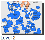
Level 2
The six districts initially demonstrating the FUSION+GIS+ONUMA Platform
will also have the campus building footprints from GIS placed in the
proper locations and spaces from FUSION will be placed in the
buildings.

Level 3
One building from each of the initial districts will also have
the actual layout of the building based on floor plans with rooms from
FUSION.
Level 4
The ONUMA System has other capabilities built into it like viewing and
editing room level furniture and equipment. As a middleware it
also links to other BIM, CAD and GIS Systems.
Functionality of FUSION+GIS+ONUMA
Platform
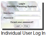
Individual User Log In
Each user has access to the proper level of detail of graphics and
data. Users can view or edit through a web browser, installing no
software. This strategy allows “viewers” to see live data as it
is made available by editors and administrators of the system.

Entire State Portfolio Level View
View all campus sites as links on a web-based map with objects having a
latitude and longitude right down to a piece of equipment in a
room. This is not a trivial accomplishment and makes the
connection of building models and GIS real in a tangible way; enabling
location based tracking of information across the entire portfolio.
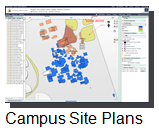
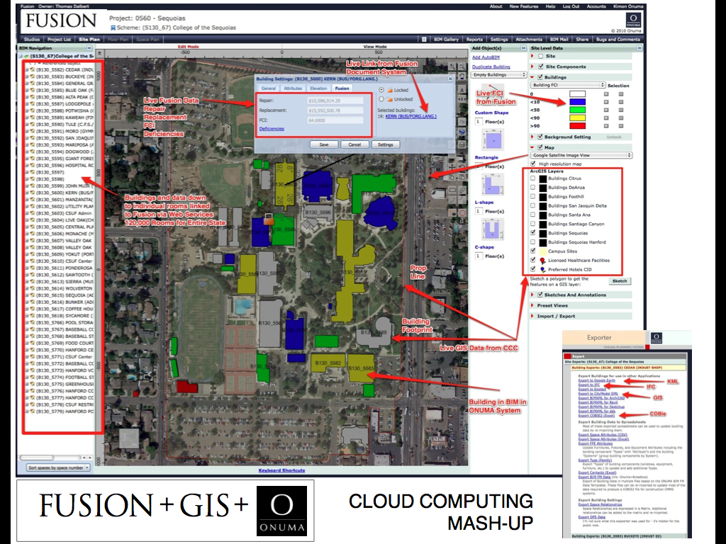
Campus Site Plans
With proper access, a user clicks on a dot that opens the site plan and
building footprints of a particular campus. Live links to
geographic data from Google Earth, the CCC GIS Collaborative Server
(with color coded building plans) and other live elements from FUSION
data can all be queried.
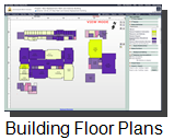
Building Floor Plans
Floor plans that are traditionally managed in static CAD or PDF plans
are made live. As data changes in FUSION changes the graphics in
the floor plans. This strategy is what allows the data to live
and be accurate over time, rather than having to constantly update it
manually.
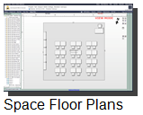
Space Floor Plans
Laying out and planning new spaces, furniture, equipment or managing
existing spaces is all possible. This is a Level 4 detail that is
available in the system but will not be used in the initial development.
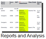
Reports and Analysis
Reports can be generated directly from the graphics. FUSION data
can also be shown in these reports. Data can also be exported in
many open standard formats such as Google Earth, BIM via IFC and
BIMXML, COBie, OGC OWS4, CSV or EXCEL Tables.
Technical Requirements
One of the most powerful aspects of the FUSION+GIS+ONUMA Platform is a
computer with Internet access is all that is needed to start
interacting with the data. No software installation is
needed. In the past, complex desk bound PC systems required
expensive software and training to retrieve basic information. In
the PC environment, “current technology” was outdated by the time the
project was finished. The new model: access data on someone else’s
infrastructure. Those barriers are removed with the FUSION+GIS+ONUMA
Platform. This allows both technical and non-technical users to
work from their platform of choice with minimal hardware requirements
and software training.
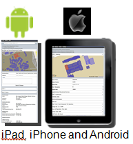
iPad, iPhone and Android
The explosion of smart phones and apps on iPhones and Androids
demonstrates the need to use simple tools to view and analyze
data. The solution shown here supports all of this and
more. The iPhone and Android UI can view and edit some data, and
view 2D graphics, which can also be used to collect field data directly
into the ONUMA System.
CLOUD COMPUTING
The
Internet has changed so much in the way we work and access
information. Smart phones and location aware services allow
instant and easy access to complex relevant real-time
information.
The old
model of “importing” all data into one monster desktop
bound system is becoming extinct. The new model of using the Internet and “services” to subscribe to information
that is the
authoritative source is the scalable solution for complex data.
FUSION+GIS+ONUMA linked together as cloud based services make this a
reality for the CCC. This initial implementation provides
exponential value but is really just the tip of the iceberg as more
functionality is added in simple and economical way as needed.
 buildingSMART alliance
Industry Foundation Classes (IFC)
Open Geospatial Consortium (OGC)
World Wide Web Consortium (W3C)
Green Building XML (gbXML)
Construction Operation Building Information Exchange
(COBie)
Open Standards Consortium for Real Estate (OSCRE)
REST and SOAP Web Services
BANG
With
FUSION as the master repository of facility data, GIS mapping the
location of campuses and buildings and ONUMA as the integrating
middleware bringing it all together -- the FUSION+GIS+ONUMA platform is
born.
OPEN
STANDARDS
Just
like the Internet is not one web site, the FUSION+GIS+ONUMA
Platform is not created around one solution. The complexities of
21st century facilities cannot be managed by any single monolithic
software.
The use of open standards will support plugging and playing different
systems. Avoiding proprietary locked systems will future-proof
the data being managed for the California Community Colleges.
As new needs arise they can be added as modules to the system.
The FUSION+GIS+ONUMA Platform builds the initial infrastructure for
this open standards implementation and invites collaborators and future
competitors to enhance the capabilities of this ecosystem. We
challenge the industry to plug in and share.
Information and Graphics
Data connected to graphics makes it easier to rapidly analyze and make
decisions with information.
Building Information Modeling (BIM)
4,000 buildings from the entire state are available at varying levels
of detail, ready to be opened in tools like Revit, ArchiCAD,
Bentley, Vectorworks, Onuma and other BIM applications.
Geographic Information Systems
(GIS)
Every piece of data is referenced to a geographic location and can be
analyzed in various GIS applications. All buildings can be opened
and viewed in Google Earth.
Facility Management (FM)
Data is formatted to be used by FM systems.
Open Standards Consortium for Real Estate (OSCRE)
All buildings can be exported in the open standard COBie format.
Computer Aided Design (CAD)
2D and 3D data for the entire state is now connected to graphics which
can be accessed in a simple format.
Three Dimensional Models
Buildings can be viewed in 3D and exported to other formats such as
Google SketchUp and BIM.
Connect with Open Standards
The platform is set up to allow exporting and importing data with open
standards exchanges such as IFC, XML, COBie, KML, CSV and other
formats.
Web Services and the Cloud
Other systems can also connect through web services. In the same
way that FUSION is connected to ONUMA System live through webservices,
other systems could also connect.
For More Information
http://www.foundationccc.org/WhatWeDo/FUSION/tabid/76/Default.aspx
http://cccgis.org
http://ONUMA.com/FUSION
About ONUMA Inc.
http://ONUMA.com
http://BIMStorm.com
http://BIMStorm.blogspot.com/
http://twitter.com/#!/BIMStorm
BIG BIM little bim
Finith Jernigan an early pioneer and leader in BIM coined the term “BIG
BIM little bim” in his book of the same title.
http://www.4sitesystems.com
About the Author
Kimon
Onuma, FAIA, has more than 27 years practicing architecture. When he
established his practice 23 years ago he used technology to support
processes that dramatically improved efficiency. His practice today is
a hybrid architectural and technology firm.
In 1994 Kimon lead his practice to be
one of the first firms to use Building Information Modeling (BIM) on
large scale US government facilities and continues to provide his
services for many US government agencies. In 2010 Onuma, Inc. was prime
on a Department of Homeland Security project with Booz Allen Hamilton
as the sub-consultant. General Services Administration (GSA) renewed
their Onuma System enterprise license of his BIM tool. The award
winning Onuma System is a web-based tool that enables users to work in
BIM with simple interfaces. Among four BIM vendors: Autodesk
Architectural Desktop, Autodesk Revit, Bentley and Graphisoft, Onuma
System is the only architectural firm that provided GSA assistance in
defining the GSA BIM Guide.
Kimon’s unique perspective spans the
realm of architecture, planning and programming. He is one of the
leading architects / technologists using Building Information Modeling
(BIM) to create custom solutions specific for the building industry.
His team today is a unique mixture of architects, planners, and
computer scientists. The core team is directly involved with all
projects and he has had recent experience managing hundreds of people
in small and large firms using BIM.
In 2008 Kimon came up with BIMStorm,
a collaborative design charrette. BIMStorm is the contraction of BIM
and brainstorm. BIMStorms demonstrate the power of cloud technologies
with the design process. BIMStorm LAX,
was a 24 hour virtual global design charrette event that took place
January 31, 2008, comprising 60 Los Angeles city blocks and over 54
million square feet. BIMStorm LAX was submitted as a project to
American Institute of Architect (AIA) 2008 Technology in Architectural
Practice (TAP) Design Awards, garnering a TAP award three months later
at the 2008 AIA National Convention. With a Woodstock theme, where
architects came together to design and collaborate in real-time, BIMStorm
LAX brought together city planners, owners, design, engineering
professionals and subject matter experts, to collaborate in low carbon,
real-time cloud charrettes.
Kimon has written for and has been
interviewed by many industry trade journals.
[an error occurred while processing this directive]
[Click Banner To Learn More]
[Home Page] [The Automator] [About] [Subscribe ] [Contact Us]